|
Contents |
|
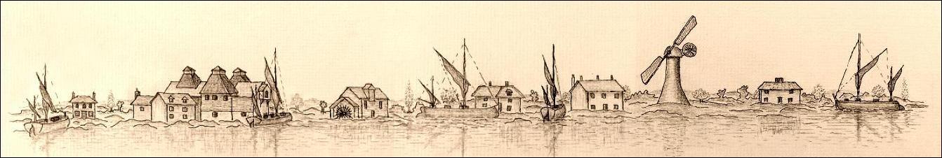
Saltcote Hall Saltworks Saltcote Maltings Tidemill Tidemill House Millhouse Mill Beach Barrow Marsh Farmhouse
Introduction
Before the seawall
was completed in the early 1800s on this section of the north bank of the
Blackwater Estuary, called Barrow Marsh
was part of a long stretch of salt marsh from Wash Brook, Goldhanger to
Heybridge. On the 1777 Chapman & Andre map the road from Goldhanger to
Heybridge and Maldon (now the B1026) is shown as dotted lines crossing the
marshes, indicating the road was not always passable at high tides...

Over the centuries this area of land had been
divided in several ways between Gt. and Lt. Totham and Goldhanger parishes to
give the inland villages access to the navigable waters and to the salt, and the Tothams each had their own north-south route to reach this part of the estuary.
Before the Reformation,
this strip of marsh land was owned by Beeleigh Abbey, and during the 18th and
19th centuries most, if not all of it, was owned by the Coe, Coe-Coape and Coape-Arnold families. The main
residence of the Coe and Coe-Coape family was Vaulty
Manor, which is within Goldhanger parish. Many of their Deeds and other
documents relating to their ownership of the Barrow Marsh features give a
Goldhanger address, which in the past has led to some confusion.
The name Barrow
Marsh is derived from the presence of various mounds that were investigated
in the past to see what they contained and establish their origin. It was
mainly that early archaeological work resulted in their disappearance.
The word Barrow
has been spelt many ways over the centuries:
Barrowe Hills, Burrowe Hills and Barrowe
Marsh, Burrowe Marsh – in ERO Deeds
Barrow Hills, Borough Hills - in Maldon & the River Blackwater, by E
A Fitch in 1898
Barrow Hills – in the Tithe Awards of 1820
& 1838
Burrow Marsh - Whites directory of 1848
Barrow Marsh Farm
Of the locations included on this webpage,
Barrow Marsh Farm is the closest to Goldhanger and some of its land is still
within Goldhanger Parish. The farmhouse was destroyed during WW-2, and today
most of the land is used a caravan site for holiday makers, due to its
proximity to the south facing bank of the Blackwater Estuary. In several Deeds in the Essex Records Office (ERO) the farm is called
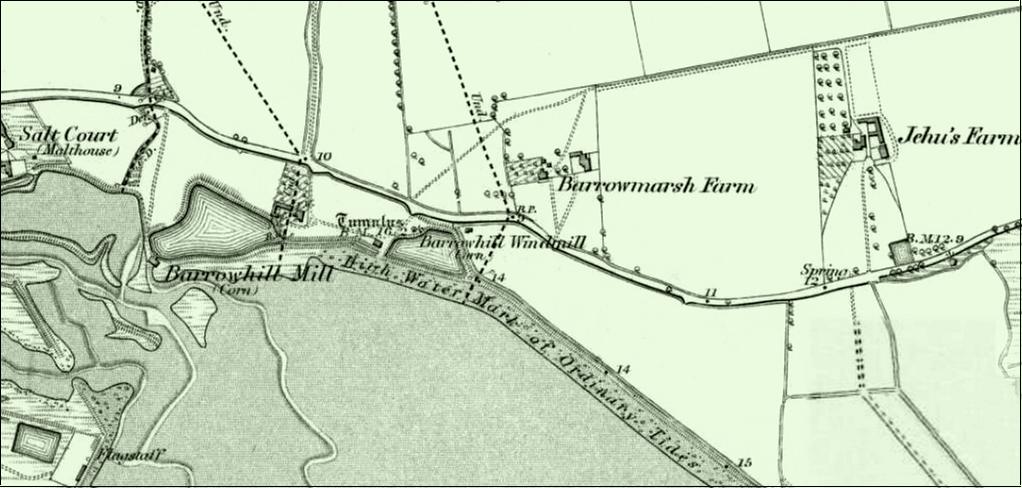
“Vans, Vanns and Vaus farm”. This map from 1895 shows Barrowmarsh farmhouse and dotted lines of the parish boundaries
between Goldhanger, Lt. Totham and Gt. Totham...


a postcard view of Barrow
Marsh Farm
The Windmill at Millbeach
Below is an extract from a paper written by Miller Christy and W H Dalton in 1925, published
in the Transactions of the Essex
Archaeological Society...
A
windmill with the suggestive name " Barrow-hill Mill" stood formerly
close to the water-side, and adjoining the present Mill Beach restaurant, which
is in the narrow tongue of Great Totham. It was probably so called because it
was placed actually on one of the Barrow hills. Mr. G. W. Johnson says (History
of Gt. Totham, p47 1831) that it "was erected about the year 1703"
(very likely in place of an earlier mill destroyed in the Great Storm) and
that, having been destroyed by a hurricane on the 30th June, 1830, it was
rebuilt in the following year.
This last mill
has now, in its turn, completely disappeared. Possibly the mound on which it
stood is that standing on the bank of a large pool of water and on which a
detached dining-hall has recently been built; or this mound may be, in whole or
in part, that of which Mr. Fitch says (Maldon and the Blackwater, p31 1896)
that it was "the result of Mr. Green's spending £200 to have his mill pond
cleared out about fifty years ago." Its base is, we judge, three or four
feet above mean sea level.
|
|
|
|
1890s sketch in...
Essex Highways, Byways & Waterways by C.R.B.
Barrett. |
photograph from
the early 1900s |

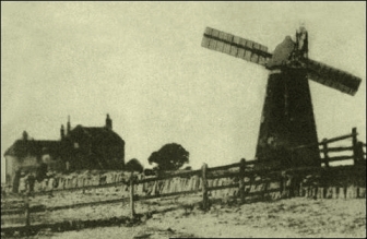
The photograph on the right above shows two
buildings in the background. The closest appears to be where the Mill Beach
public house is now located and was most likely the millhouse for the windmill
at that time. The further building is probably the millhouse for the tidemill,
still located at the east end of the tidemill pond. This can be confirmed by a
close inspection of the 1873 map and the recent aerial view shown below. The
Christy and Dalton extract above indicates that the “Mill Beach
restaurant/dining-hall” was created around 1925.

Many postcards were produced over a twenty
year period that indicate in it’s day the Mill Beach Hotel was a high-class
establishment that attracted affluent clientele with the means of transport to
get there. Here are four typical postcards from that period...
(select
image to enlarge and zoom in)
The Tidemill
There are several indications that there was
once a tidemill or watermill near the village.
In Goldhanger - an Estuary Village the late Maura Benham wrote:
"The Jarpenville family settled at
Little Totham in the 12th century . . . part of the estate was handed over to Philip
and Matilda in 1271 during the lifetime of Matilda's father, Roger de
Jarpenville, and included was a water-mill at Goldhanger
with suits and all other things appertaining to that mill".
The Evangelical
Magazine and Missionary Chronicle of 1842 advertised for an apprentice...

In Heybridge in the Nineteenth and
Twentieth Centuries, Beryl
Claydon wrote:
“The tide mill, located in the section
of the river known as Mill Reach, is recorded in documents as far back as 1819.
As the tide rose, water was allowed to flow into three enclosed ponds. When the
tide began to drop, sluices would divert the flow past the mill building and
drove a large water wheel. The mill was converted to steam, but then demolished
in 1892.
Sluice gates were wound up and down by
turning a handle. As the gates were raised, a frame of enclosed mesh that
captured eels and flounders was placed in front of the sluice gate. The eels
were placed in a bucket with eel shears and covered with sacking to prevent
their escape”.
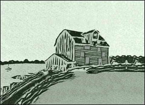
The 1873 map below identifies both the Barrow
Hill windmill and the Barrow Hill tidemill/watermill. Unfortunately no
photograph or sketch of the tidemill has been found, but it was very likely to
have been a simple wooden weather boarded structure and similar to others in
the region, particularly the tidemill at Thorrington. near Brightlingsea...
|
|
|
|
1873 map |
how the tidemill
may have looked |
|
|
|
|
|
|
|
aerial view of
the location today |
|

Deeds dated 1845-1851
(ERO D/DU 627/4 - and summarised below) identify both mills as
belonging to Coape family.
This extract from the
1907 Essex Review, refers to a
corn-riot at “Burrow-hills” in 1629...

A comparison of dates
in various documents indicates this was associated with the tidemill rather
than the windmill.

Although no photos or drawing of the tidemill
itself have been found, there are photographs available of the tidemill house
which is still at the side of the mill pond and old postcards of that are
available. These pictures show:
The tidemill house in the 1930s and 40s then
operating as a guest house; the tidemill house beside the millpond and close to
the estuary; two views from the beach in the 1920s; and as it appears in recent
years now surrounded by trees and hardly visible from public paths.
(select
image to enlarge and zoom in)
The Saltworks and Saltcote Mill
The saltworks has very ancient origins and
has been described as both the Heybridge saltworks and Maldon saltworks, and has
also been recorded with a Goldhanger address. The orgins of saltworks at
Heybridge and Goldhanger go back to the Bronze age and the formation of
Redhills. “Salthouses” at Heybridge and Goldhanger were listed in the Domesday
Book, along with eighteen other locations around the Blackwater Estuary. There
is more about the local saltworks at...
Salt
Extraction on the north bank of the Blackwater
Between 1820 and 1825 the Heybridge saltworks
closed down and the business moved to the river bank in Maldon and a new mill
and malting building was build at the site adjacent to the old saltworks
building. The demise of the salt extraction at this location could well have
been in part the result of a new seawall was built along Barrow Marsh and
around the saltworks in 1807 (see letter below). A
1873 map shows the “Salt Court (Malthouse)” located close to the tidemill and
adjacent to the seawall...

The photo on the left below, taken in the
1970s, shows the two saltworks buildings in the foreground in a state of
dereliction with the malthouse in the background. The photo on the right, taken
in 2016, shows the two saltworks buildings in the foreground, having restored
and converted to a private residence, with the malthouse in the background,
which was converted into residential flats and holiday accommodations in the
1980s.
|
|
|


Canterbury Farm
Letters
& Papers of Henry VIII, dated 1553, refers to lands called “Caunterberyes in
Goldaunger”...

Also ERO D/DVz/359 (shown
below) dated 1569 refers to “Canterberies at Goldhanger”. These documents
would suggest that the farm which is near Jacobs Farm on the Goldhanger Road and
quiet close to Heybridge , was once within Goldhanger parish. It is now called
Canterbury Farm. The name appears to originate from an owner or farmer called
Thomas Caunterbury in the 1381, rather than any connection with Kent or an
archbishop.
Chigborough Farm
Surprisingly, three references to Chigborough
Farm with a Goldhanger address have been found, although the two in ERO as also associated with Great and Little Totham. However, a
newspaper advert of 1855 for properties of the Coape family refers only to it
being at Goldhanger. This may a reflection of its ancient connections with
Beeleigh Abbey, or simply that the Coape family had a preference for a
Goldhanger address.
The Ancient Tumuli
A great deal has been written about the
mounds, burrows or tumuli around the Barrow Marsh area. Up to 25 were recorded
and investigated in the past to establish what they contained and to determine
their origin, and this early archaeological work was largely responsible for
their disappearance. Many early antiquarians believed they were burial mounds
resulting from the Battle of Maldon. However the two more recent reports cited
below dismiss that theory. There were Tumuli at the site of Salcote Mill which
were investigated when the maltings was built in the 1800s and then destroyed
during the construction work.
an extract from... The Maldon Archaeological and Historical Group - Maeldune, Battle site, by Barbara Smith:
In
'The History and Antiquities of The County of Essex' Morant noted that in 1768
there were in Totham parish, by the shore, many tumuli or mounds of earth,
called Borough Hills, which seemed to be the graves of Danes or Saxons slain in
assaulting and defending the area. Similarly in 'Maldon and the River
Blackwater' (1898), Fitch noted that some of these tumuli were in Heybridge
parish but the most noticeable were in that part of Great Totham "that
runs down to Blackwater Bay".
Both
authors refer to the shore-line at Mill Beach. A mound was opened in 1773, but
no antiquities were found. Possibly the mounds were soil heaps resulting from
the digging of the mill pond for Heybridge Tide Mill built during the 18th
century.
Below is an extract from a paper written by Christy Miller and WH Dalton in 1925 and
published in the Transactions of the
Essex Archaeological Society...
Two
Large Groups of Marsh Mounds on the Essex Coast
IV - Description and known history of
the group near Maldon
This
group, which was entirely destroyed long since, was known as the ‘Barrow’, or
‘Borough’ hills. It is not now possible to give any but a vague description of
this group as it existed originally, owing to its complete disappearance.
Fortunately, however, the group attracted the notice of several of our early
local historians, and their remarks, though very meagre, give us some idea of
what it was like. We have, however, the testimony of antiquaries as to what
they sa w-in one case, over a century and a half ago, when some of the hills
were in course of demolition.
How
many hills there may have been originally, it is now impossible to say; but
most of the early Essex historians speak of "many”, and one speaks of
"near fifty". Frequent reference is made to the lands, pastures, and
marshes "known as Barrow-hills and Barrowmarsh," in Goldhanger, Great
Totham, and Little Totham. It remains to consider the various theories which
have been put forward to account for these curious groups of mounds and to draw
conclusions...
(a)
The
Burial-Mound Theory - Mr. G W Johnson adopts the view. He says of the hills
that "They undoubtedly mark the burying places of the Saxons and Danes”
who fell in some one of the numerous conflicts which took place in this
neighbourhood between those nations. I am "inclined to consider it to have
been that in which Brythnoth, Ealdorman of Northumberland and Governor of
Essex, fell in 991".
However
tempting the theory that these mounds are sepulchral memorials, one cannot get
away from the awkward fact that, of all those which have been opened, not a
single one has been found to contain anything even suggesting an interment
therein. Equally awkward is the fact that none of the mounds occupy the kind of
situation in which burial-mounds are generally placed-namely, on high ground;
but they all occupy, on the contrary, ground so low that it is below high-tide
level and, before the construction of the seawalls, must have been constantly
under water. One cannot imagine either sepulchral or memorial mounds being
erected in such a situation.
(b)
The Cattle-Refuge Theory - If they were cattle- shelters, they would not be
found closely grouped together in considerable numbers at two spots only and no
other such anywhere on our marshes.
(c)
The Red-Hill Theory - Red-hills occur almost invariably close to the inner edge
of the marshes, where the dry land begins to r ise. These other mounds occur,
not near the rising ground, but right out on the level marshes and close to the
salt water. Red- bills consist throughout of a fine burnt clay, having a
curious dull-red tinge which is quite unmistakable by those familiar with it.
Nevertheless, it seems possible that the mounds in question may be built upon
older red hills.
(d)
The Beacon-Mound Theory - This is a highly-improbable hypothesis, the position
of the mounds and th eir c lose grouping being both against it.
(e)
The Land-Mark or Sea-Mark Theory - It is hard to imagine that many could be
required together or what particular service any could be in such low positions
as those occupied by the groups in question.
(j)
The Gun-Placement Theory - thrown up at the time of the Dutch invasion of 1667.
It has been shown that some of the mounds existed before 1667.
It
seems then, that the various hypotheses which have been put forward all fail
completely.
What
is the approximate age of these mounds?
- We know that the Barrow Hills group was in existence at least as early
as 1574. There is no evidence that they are of great antiquity; for nothing
which can be regarded as prehistoric, or even as Roman or Saxon, has been found
in them.
Next,
what was the probable origin and use of the mounds? - It is admirably summed up in Mr. Francis
Reader's report to the Morant Club... There is little doubt that the 'tanks'
were the main object of the construction of the works; and that they may be
regarded as dumps of refuse, the surplus of what was not required for forming
banks around 'sun pools'.
If
the tanks were the principal feature of these works, what were they used for? -
Two kinds of tanks have been used commonly on the Essex marshes, of w ich we
still have existing examples - one for the preservation of fish, the other to
hold seawater to be evaporated by the sun, the brine thus produced being
subjected to further heating by fire, thus producing salt crystals.
We
cannot regard the mounds as "contingencies" or as "dumps of
refuse" merely. It seems to us that the piling of waste material into
mounds 15 or 20 feet high is far from being the most convenient way of
disposing of it, especially where there is ample space all round for disposing
of it, as there is on these marshes. It seems to us, therefore, that the mounds
must have served some definite purpose, as mounds, though we are unable to
indicate the nature of that purpose.
Summary of Essex Records Office held documents [with
the word Goldhanger highlighted by the author]
1569 D/DVz
359 Vaizey Family of Halstead and North Essex
Deed of Livery...
including manor of Fallyfantes ... grange of Langwyke, in previous possession
of Monastery of Coggeshall ... Canterberies in
Goldhanger, previously in possession of monastery of Beeleigh.
1646 D/DU
1675/1/2
Toft and 40a. of
‘upp Lande’ and 40a. of marsh called Barrowe Hills
otherwise Burrowe Hills and barrowe Marsh otherwise Burrowe Marsh in
Great Totham., Little Totham, and Goldhanger,
now occupied by William Sidey.
1676 ERO
D/DU 1675/1/1-35 Deeds of Barrow Hill Farm, Goldhanger
Messuage called
`the salt coate house’ and loft called Barrow Hill otherwise Burrow Hills
Barrow Marsh otherwise Burrow Marsh, containing 80a., in Great Totham, Little
Totham, Heybridge and Goldhanger
1697 D/DU
1675/1/14 D/DU 1675/1/1-35 Deeds of Barrow Hill Farm, Goldhanger
Assignement of
remainder of mortgage term (demise for 1000 years)
(i) Francis
Freshfield mariner of Colchester and Richard Waller merchant of Colchester;
(ii) Charles Coe grocer of Maldon; (iii) William Coe linen draper of Maldon
1792 extract from Origins and failure of New South-End,
written by J. R. Smith and published by
ERO & Univ. of Essex in 1991
“...in 1792 the
Pattison family began operating a bathing machine and lodgings at Burrow Hills in Goldhanger”.
1811-1817 ERO
D/DU 627/14
Messuage, windmill,
watermill called Burrow Hill Mills, granaries and land (10 acres) in Great and
Little Totham.
1819 ERO
D/B 3/3/664/1 Court Papers
..to avoid payment
of tolls on goods imported by ship and that Thomas Plume ...keepeth and
maytayneth a Wharfe late made and erected...at Heigh Bridge...and the said
Wm.Syday hath also lately erected and made and keepeth a Wharfe at Barrow hills
[in Goldhanger]... at which Wharfe in every
of the said five years now last past he hath landed charged and discharged
bought and sold Iron two hundred quarters of Wheate, two hundred quarters of
Rye, two hundred quarters of Malte, two hundred quarters of Oates, two hundred
loades of Weed and other Goods and Wares.
1845-1851 ERO D/DU 627/4
Deeds of Coape Family In Goldhanger
Deeds of
Chigborough Farm (113 acres) in Goldhanger
and Great and Little Totham; Barrow or Barrow Marsh alias Vans Farm (91 acres) in Goldhanger and Little Totham; Cobbs and
Sewells Farm (101 acres), lands [21 acres] [field-names] and marshes (38 acres)
near Goldhanger Wash; Ovesey Island Farm (242 acres) in Great Totham; Vaultys
Farm (95 acres) in Little Totham and Goldhanger;
The Wash Farm alias Gardners Farm and Decoy Farm (190 acres) and saltings (80
acres) in Great and Little Totham; messuage, windmill and watermill called Barrow
or Burrow Hill Mills, granaries and lands (10 acres) in Great and Little Totham
and Heybridge; and messuage with salt office and yards called the Salt Cote and
land (1 acre) at back of Malting and adjoining Salt Cote March and Salt Pond,
and cottage in Little Totham, all in Heybridge and Little Totham.
1824 and 1839 D/DOp
B17 Letters and draft leases
Burrow
Marsh otherwise Vaus Farm in Goldhanger and Little Totham.
1850 D/DU
1675/1/20
Henry Coe Coape
esq. of Goldhanger and James
Weston gentleman of Fenchurch St. City of London to Rt. Hon. Lady Adelaide
Georgiana Fitz Clarence spinster of Addision Road Kensington Middlesex.
Messuage called Chigborough Farm (113a. Or.7p.) in Goldhanger,
Great Totham and Little Totham, occupied by Sarah, Elizabeth and Anna Carter;
freehold parts of messuage called the Barrow or Barrow
Marsh otherwise Vanns (94a. or 27p.) in Goldhanger and Little
Totham, occupied by Thomas Challis Carter.
1918 D/P 112/28/1 Sale catalogue
Sale catalogue of Barrow Hill Farm (90 acres) in Goldhanger
Newspaper article and letter
Advertisement in the Essex Herald of 1855 for
the sale of properties of the Coape family at Goldhanger and Barrow Marsh...

Below is part of a letter dated 1807,
published in the Transactions of Arts,
Manufactures, and Commerce Society, from a William Lawrence, after being
awarded a silver medal for his achievements in building a seawall across the
Barrow Marshes. The new wall enabled the saltworks to continue to operate, but
admits that several tumuli were destroyed. (in fact it only operated for
another 14 years)...

top surrounding
area Coe-Coape and Coape-Arnold families home